Reviews
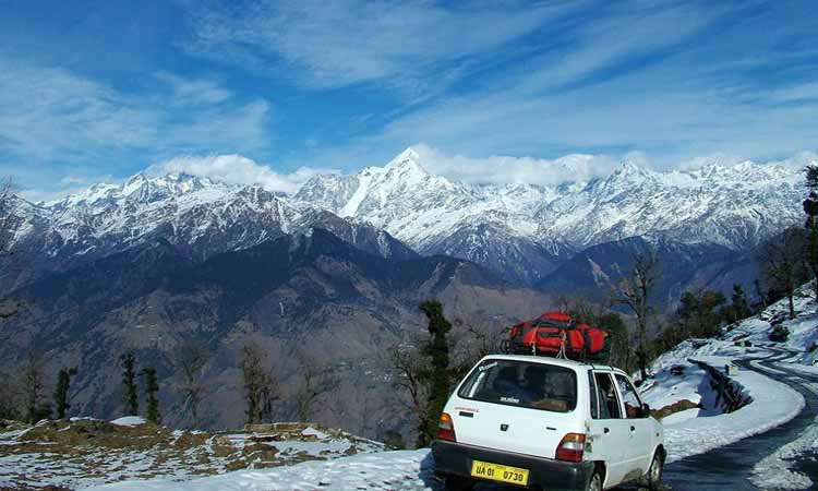
Transport
By Air, By Train, By Bus.
About Munsiyari
Munsiyari ( मुनस्यारी ) is the name of the sub-division headquarters, a conglomeration of revenue villages and it also refers to the entire region as Munsiyari Tehsil and Sub Division in the Pithoragarh District in the hill-state of Uttarakhand, India.
It is a hill station and lies at the base of the great Himalayan mountain range, at an elevation of about 2,200 m (7,200 ft) and is a starting point of various treks into the interior of the range.
In local parlance, the name 'Munsiyari' refers to a 'place with snow'. Situated on the banks of Goriganga river, it is a fast-growing tourist destination, and mountaineers, glacier enthusiasts, high altitude trekkers and nature lovers commonly use it as their hub or base camp. Munsiyari also falls on the ancient salt route from Tibet and is at the entrance of the Johar Valley, which extends along the path of the Gori Ganga river to its source at the Milam Glacier. It is inhabited mainly by people of a few different caste groups including the Shauka tribe, dalits or Scheduled Castes and people categorized in other general castes comprising Kshatriya's, Pandits with a few Sikhs, Christians and Buddhists.
Munsiyari bazaar is a conglomeration of revenue villages and is not categorized as a town. The bazaar area comprises the villages of Malla Ghorpatta and Bunga, while Naya Basti, Sarmoli, Nana Sem, Jainti, Papdi villages form the periphery of the area popularly called Munsiyari. The main bazaar area faces east towards the Himalayan Panchachuli ranges.
The upper part of Munsiyari is called Malla Johar, which comprises 14 trans-humant alpine villages, that are seasonally occupied during the months of May to early November.
Munsiyari History
During a summer festival organized in Munsiyari market in 2013, a proposal for granting Munsiyari the status of Nagar Panchayat (lower level Municipality) was passed by the locals. Gram Panchayats attached to the Munsiyari market had also given their consent for this. On 28 February 2014, the Uttarakhand Cabinet decided to grant Nagar Panchayat status to the towns of Munsiyari, Chaukhutia and Naugaon. Shortly afterwards, the then Chief Minister Harish Rawat made an announcement confirming this move while on a visit to the town. The municipal area was to be created by incorporating 5 Gram Panchayats: Mallaghorpatta, Tallaghorpatta, Bunga, Sarmoli and Jainti. An official notification was issued on 7 October 2014, but due to major opposition by the Gram Sabhas, the Nagar Panchayat could not come into existence. In June 2015, several government officials visited the area and tried to initiate talks with local villagers. After all the talks failed, the notification that allowed the formation of Nagar Panchayat was revoked on 22 August 2016.
Climate and Weather
Munsiyari enjoys a temperate climate with the maximum reaching 30 degree C and the minimum at -12 degree C.
Best time to Visit Munsiyari
March to April: The entire Forest area turns red with rhododendron flowers, with snow capped Himalayas distinctly visible makes it an awesome site well worth visiting.
The Best months to visit Munsiyari are: March, April, May, October and November.
Trekking Routes
The main trekking route is to Milam Village and Glacier
Milam Glacier : Munsiyari is the point from where the trek to Milam glacier commences :
Ralam Glacier
Places To Visit
Gori Ganga River
Gori Ganga (also Gori Gad) is a river in the Munsiari tehsil of the Pithoragarh District, part of the state of Uttarakhand in northern India. Its principal source is the Milam Glacier, just northeast of Nanda Devi along with the Glaciers of the Ralam River, and the Pyunshani and Uttari & Dakshini Balati Glaciers that lie on the western face of the Panchachuli Peaks.
The alpine trans-humant village of Milam is located one kilometer below the snout of the glacier. Here a left-bank stream called Gonka joins the Gori. The valley provides the approach route for access to peaks such as Nanda Devi East, Hardeol, Trishuli, Panchchuli and Nanda Kot.
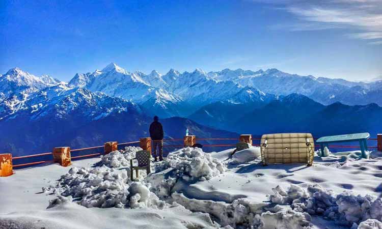
Khalia Peak (3747 meters / 12290 feet)
The Khaliya Top is a meandering meadow surrounded by snowy peaks, offering an awe-inspiring view of the mystical land of Kumaun. The Khaliya Top is perched at an astonishing altitude of 3500 metres above sea level and located near Munsiyari in Pithoragarh district of Uttarakhand.
One can savour the panoramic views of the majestic Panchachuli, Rajrambha, Hardeol and Nanda Kot peaks from the Khaliya Top.
Thamri Kund
Tamri Kund or Thamri Taal is a small pond located in the forests of Munsiyari region of Uttarakhand. The Kund is revered by the locals to bless the region with rain in case there is insufficient rainfall.
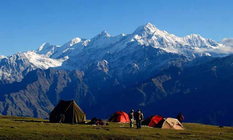
Panchachuli Peaks
The Panchchuli peaks are a group of five snow-capped Himalayan peaks lying at the end of the eastern Kumaon region, near Munsiyari, in Pithoragarh district of Uttarakhand state. The peaks have altitudes ranging from 6,334 metres (20,781 ft) to 6,904 metres (22,651 ft).
Birthi Falls
The Birthi Water Falls is located about 14 km from Tejam near Munsiyari in Pithoragarh district of Uttarakhand. This cascading fall surges from 400 feet above sea level and can also be reached from Kalamuni Pass. The Birthi Falls is about 35 km from Munsiyari and can be approached easily by a short trek.
Betulidhar
Betulidhar is a colossal garden blossomed with scarlet coloured rhododendrons. It is one of the best places to visit during the winter season as this place offer exciting skiing opportunities. The ski months begins from December to February.
Tribal Heritage Museum
Established in 2000, Tribal Heritage Museum is a small cultural private museum located in Munsiyari town of Uttarakhand. The museum showcases the history, culture, traditions and lifestyle of Bhotia people who are ethno-linguistic group of people residing in the upper Himalayan valleys of the Kumaon and Garhwal divisions of Uttarakhand.
Nanda Devi Temple
Nanda Devi temple dedicated to Goddess Nanda or Parvati is a Hindu sacred site where the faith of many devotees abides. This religious site can be reached by commencing a swift 3 km stimulating trek from Munsiyari town perched at 7,500 feet above sea level. It is one of the oldest temples in Uttarakhand.
How To Reach
By Air
There is no airport in the town of Munsiyari. The closest airport is the Naini Saini Airport, which is around 125 km from the town. However, even though it is the closest in distance, no commercial flights operate from the airport, but the government plans to begin commercial flights to better serve tourists visiting the Himalayan region. The next closest and functioning airport is the Pantnagar Airport at a distance of around 336 km. The Pantnagar Airport has regular flights to and from New Delhi via Air India Regional. The closest international airport to Munsiyari is the Indira Gandhi International Airport in New Delhi, at a distance of around 652 km. The Indira Gandhi International Airport is well connected to several cities in and out of India.
By Rail
Munsiyari has no railway station of its own. The closest railway station is in Tanakpur at a distance of 274 km. There are four trains connecting Tanakpur to Philibhit. The next closest railway station is in Kathgodam at a distance of around 300 km. The railway station has several trains passing through it, which connect it to several cities and towns in India. A few of the major cities connected to the Kathgodam Railway Station are New Delhi, Kanpur, Kolkata, Lucknow, Patna, and Jaipur.
By Road
There are government, as well as, private buses to Munsiyari. The Uttarakhand Transport Corporation has buses to Munsiyari from New Delhi and Madkot. The journey from Delhi can be tiring as it is a 730 km long stretch that needs to be covered. Madkot is 134 km away from Munsiyari. Buses can be boarded at ISBT Anand Vihar in New Delhi. As the journey from Delhi to Munsiyari can be quite long and tedious, breaking the journey at various points along the way is recommended. Catching a bus from either Almora or Pithoragarh before finally reaching Munsiyari is a better option.
Reviews
728 Reviews
Overall Rating
Mountains are always an attractive tourist destination. Apart from Himachal Pradesh and Kashmir, which are both very famous tourist destinations, Uttarakhand is a developing mountain state that has many hidden gems just being discovered. View is pretty beautiful.
Overall Rating
Birthi Falls is a beautiful place surrounded by nature and snow clad mountains all around. The Birthi Falls is one of the beautiful nature's gifts located on the way to Munsiyari via Thal surrounded by tall green Hills and can be seen from the miles away. To reach near the falls a few minutes trekking is needed from the road. The fall is at a height of around 400 feet and is located in Munsiyari (on the way to munsyari). The place is a must go and certainly the place is a much more to see and visit. Water is ice cold in summer.
Other Tours
Chardham Yatra
 Pilgrimage, Temple, Rivers.
Valley, Mountains, Himalayan View
Family/Group
Local Sightseeing
All Taxes Inclusive
Trekking Tour
Peaks, Grasslands, Trekkers.
Valley, Mountains, Himalayan View.
Family/Group.
Local Sightseeing.
All Taxes Inclusive.
Rural Tourism
Pilgrimage, Temple, Rivers.
Valley, Mountains, Himalayan View
Family/Group
Local Sightseeing
All Taxes Inclusive
Adventure Tour
Peaks, Grasslands, Trekkers.
Valley, Mountains, Himalayan View
Family/Group
Local Sightseeing
All Taxes Inclusive
Pilgrimage Tour
Pilgrimage, Temple, Rivers.
Valley, Mountains, Himalayan View
Family/Group
Local Sightseeing
All Taxes Inclusive
Yoga & Meditation Tour
Pilgrimage, Temple, Rivers.
Valley, Mountains, Himalayan View
Family/Group
Local Sightseeing
All Taxes Inclusive
Wild Life Tour
Jeep, Elephant & Canter Safari
Valley, Mountains, Himalayan View
Wild Life Movie Show
Local Sightseeing
All Taxes Inclusive
Jim Corbett Tour
Jeep Safari, Canter Safari
Wild Life Movie Show
Temple, Rivers, Landscape
Local Sightseeing
All Taxes Inclusive
Wellness & Spirituality
Pilgrimage, Temple, Rivers.
Valley, Mountains, Himalayan View
Family/Group
Local Sightseeing
All Taxes Inclusive
Rishikesh Tour
Pilgrimage, Temple, Rivers.
Valley, Mountains, Himalayan View
Family/Group
Local Sightseeing
All Taxes Inclusive
Kausani Tour
Valley, Mountains, Himalayan View
Lake, Temple.
Bonfire (During Winters)
Wild Life Movie Show
All Taxes Inclusive
Nainital Tour
Valley, Mountains, Himalayan View
Lake, Temple.
Bonfire (During Winters)
Wild Life Movie Show
All Taxes Inclusive
Kedarnath Vasuki Trekking Tour
Pilgrimage, Temple, Rivers.
Valley, Mountains, Himalayan View
Family/Group
Local Sightseeing
All Taxes Inclusive
From ₹ 2,400/ Per Person
Valley of Flower Trekking Tour
Pilgrimage, Temple, Rivers.
Valley, Mountains, Himalayan View
Family/Group
Local Sightseeing
All Taxes Inclusive
From ₹ 3,500/ Per Person
Dayara Bugyal Trekking Tour
Pilgrimage, Temple, Rivers.
Valley, Mountains, Himalayan View
Family/Group
Local Sightseeing
All Taxes Inclusive
From ₹ 3,200/ Per Person
Chopta Trekking Tour
Pilgrimage, Temple, Rivers.
Valley, Mountains, Himalayan View
Family/Group
Local Sightseeing
All Taxes Inclusive
From ₹ 2,800/ Per Person
Panch Kedar Trekking Tour
Pilgrimage, Temple, Rivers.
Valley, Mountains, Himalayan View
Family/Group
Local Sightseeing
All Taxes Inclusive
From ₹ 3,600/ Per Person
Har Ki Dun Trek Tour
Pilgrimage, Temple, Rivers.
Valley, Mountains, Himalayan View
Family/Group
Local Sightseeing
All Taxes Inclusive
From ₹ 3,399/ Per Person
Bigul Village Tour
Village Tourism, Temple.
Valley, Mountains, Himalayan View.
Panchachuli peak, Dholinaag Temple
Local Sightseeing.
All Taxes Inclusive.
From ₹ 2,600/ Per Person
Nainidanda Village Tour
Village Tourism, Temple.
Valley, Mountains, Himalayan View.
Trekking, Hiking, Camping.
Local Sightseeing.
All Taxes Inclusive.
From ₹ 1,900/ Per Person
Sankri Village Tour
Village Tourism, Temple.
Valley, Mountains, Himalayan View.
Trekking, Campfire, Camping.
Local Sightseeing.
All Taxes Inclusive.
From ₹ 2,100/ Per Person
River Rafting Tour
Welcome Drink On Arrival
Pilgrimage, Temple, Rivers.
Valley, Mountains, Himalayan View.
Local Sightseeing.
All Taxes Inclusive.
From ₹ 2,000/ Per Person
Tiger's Foot Prints Tour
Welcome Drink On Arrival
Jeep Safari, Canter Safari
Wild Life Movie Show
Bonfire (During Winters)
Local Sightseeing
All Taxes Inclusive
From ₹ 2,500/ Per Person
Corbett Rajaji Wildlife Safari Tour
Welcome Drink On Arrival
Jeep Safari, Canter Safari
Wild Life Movie Show
Bonfire (During Winters)
Local Sightseeing
All Taxes Inclusive
From ₹ 4,600/ Per Person